Read the ground before you go.
Explore USGS LiDAR terrain, compare the evidence behind a 0-100 favorability score, and keep your places, photos, and field notes together. Start from a geotagged photo or a place on the map. Free on Android and iPhone, with optional Pro and Lodeline+ upgrades.
Favorability is not proof of gold. Check current claims, ownership, and access.
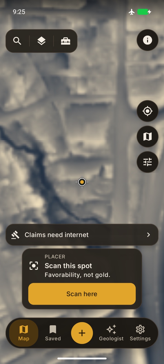
Local Relief in the Android app. Captured from a saved map with connectivity off.
- Built on USGS 3DEP LiDAR — no API key
- Pro is a one-time upgrade
- Works offline — map packs for the field
- US-wide — anywhere USGS LiDAR reaches
- Starts from a photo — snap it → terrain + score
Photo in. Game plan out.
From a snapshot to a scored spot with a briefing — before you burn a tank of gas.
Point at a spot
Open a photo you took in the field — Lodeline uses the location saved in it — or pan the live LiDAR map to any creek, bench, hillside, or bend in the US.
Get a favorability read
Lodeline scores the landform 0–100 (LOW / MODERATE / HIGH) and breaks down the reasons — drainage, slope, benches, landscape position.
Scout smarter
Save the spot, ask the AI geologist why it scored that way, group it into a trip, then verify the land status before you dig.
A full prospecting arsenal in your pocket.
Pan, sluice, highbank, dredge, detect, dig, or chase hardrock — pro-grade tools for reading the land.
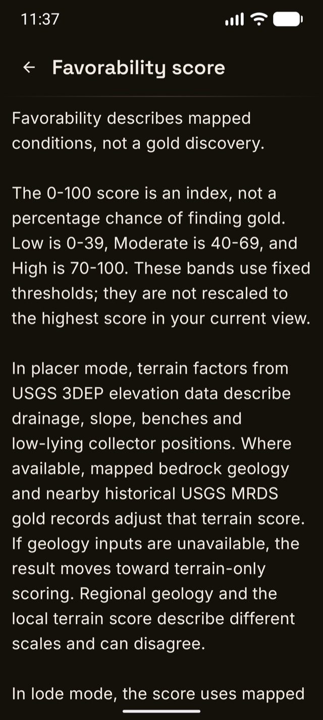
The Android explanation keeps the meaning and limits of the score visible.
A score you can actually reason about.
Where the inputs support a score, Lodeline shows a 0-100 terrain favorability index with its contributing factors. Inspect drainage, slope, landscape position, and mapped geologic context instead of relying on the number alone. The result helps organize research; it does not measure gold content or predict a discovery.
- Legible factors, not magic — water collection & drainage, favorable slope, benches & breaks-in-slope, low landscape position, each with its own bar.
- Ask the AI geologist Plus — tap the button right on the sheet for a grounded field briefing of what the terrain is doing and what to look at on the ground.
- A high score reflects the model's inputs and assumptions. It is not a probability of finding gold.
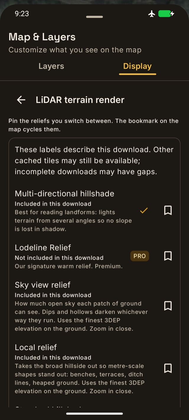
See which terrain views your downloaded map includes.
Compare terrain views. Look closer at the landforms.
Compare aerial imagery with USGS elevation renderings to investigate slopes, benches, drainage patterns, and possible ground disturbance. Adjust opacity to keep the surrounding landscape in view. Detail depends on the source survey and local coverage. Pro adds Lodeline Relief, an alternative rendering for comparing subtle landforms.
- Satellite + LiDAR hillshade basemaps, with adjustable terrain opacity.
- Lodeline Relief Pro — an additional terrain view for comparing benches and slope breaks.
- Favorability heatmap — fixed Low, Moderate, and High score bands; panning does not rescale the colors.
- Mineral occurrences overlay Pro — USGS MRDS records, framed honestly: historical records, not active claims or proof of gold.
Historical records — not active claims, and not proof of gold. Always verify land status.
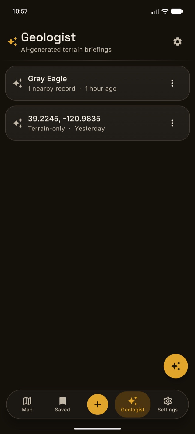
Android Geologist library. Saved briefing entries shown are examples.
A geologist in your pocket — for any spot on the map.
PlusUse Ask the AI geologist to discuss the available terrain context, mapped geology, and nearby historical mineral records. References, distance, and direction help you follow up on a record. Regional geology is not a direct measurement of the rock at your feet, and AI explanations can be wrong. Review the evidence before acting. Lodeline+ adds follow-up questions and trip-planning tools; your first three briefings are free.
- Grounded briefings — nearby historical records, mapped geology, and terrain context to check against the cited sources.
- Photo reads — show the geologist a photo of the bank, the gravel, or your pan and it tells you what it sees.
- AI trip planner — turn your saved spots into an ordered scouting route.
- AI area intel — one tap analyzes the whole view and returns ranked spots, each with a short grounded "why".
- AI-structured dig log — jot a rough field note and the AI cleans it into a tidy entry.
Placer or lode — pick your hunt.
One toggle switches the whole scoring model. Placer reads stream gold the classic way — terrain traps (drainage, slope, benches) fused with bedrock geology. Lode goes hard-rock: gold-permissive bedrock, USGS gold districts, and the density of historical gold occurrences around your point. Same honest 0–100 scale, same "show your work" breakdown — tuned to how you actually prospect.
- Two-axis score — "Gold country" (regional geology) × "Spot" (the trap at your exact point), so you always see why.
- Best reaches near you — ranks the real mapped stream channels around you and pins the top ones A, B, C on the map.
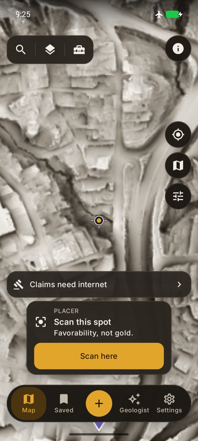
A real saved Sky View map in airplane mode. Current claims still need internet.
Everything you scout, saved and ready — even off the grid.
Save spots as waypoints and record GPS tracks as you walk the ground. On Android, save Sky View and Local Relief with Detail or Finest before leaving signal. Open the saved area and test it in airplane mode. Downloads cover the selected area and views; live claims, parcels, and online services still need a connection. BLM land-status and mining-claims overlays are free for everyone; Pro adds the USGS MRDS mineral-occurrence layer and county parcel boundaries so you can do your homework before you set out.
- Waypoints & GPS track recording — your scouting log, on your phone. Trips & the dig log Pro group the day and record what you actually panned.
- Offline map packs Pro — LiDAR + satellite tiles cached for no-signal country.
- BLM land-status & claims overlays (free) + MRDS mineral occurrences Pro — research records and check current access separately.
- Parcel boundaries & owner of record Pro — county parcel lines in MT, NC, WA, CO & VA statewide plus gold-district counties in CA, OR, ID, AZ, NV, GA & SC, with the owner where counties publish it. Approximate GIS lines — never permission to enter.
And the rest of the kit.
- Elevation & slope transect Pro — drag a line, or drop Measure points and open an elevation profile from the same tool.
- Downstream catch-finder Pro/Plus — traces where runoff is likely to drop material below your pin, with honest catch-geometry scores (never mixed into favorability).
- Ground disturbance (beta) Pro/Plus — scans nearby 1 m LiDAR for surface scars and pits worth a closer look — observations only, never "dig here."
- Track backtrack — while you walk a track, see how far back to the start along the path you already walked.
- Bulk GPX / KML export Pro — send spots, trips, and tracks to any GPS app, or open straight in Google Earth. Single-track export is free.
- River flow & daylight — live USGS gauge flow and sunset time for the day you're planning.
- HD aerial close-ups Pro — USGS NAIP imagery when you zoom in tight.
- Contours & forest roads — USGS contour lines and USFS motor-vehicle roads to plan the walk in.
- Dig log & field finds Pro — record what you actually panned, honest sample by sample; jot a rough note and the Lodeline+ AI writes it up.
- Lat/Lon · UTM · MGRS — tap the readout to cycle formats; long-press to copy. Metric or US units.
- Folders & organization — file spots, trips, tracks, and AI insights your way. An in-app What's-new tracks every update we ship.
Free like a full toolkit. Not a free sample.
Start with terrain views, the favorability score, and tools for keeping track of your field research. A free account is required. Pro adds the extended field toolkit; Lodeline+ adds ongoing AI and cloud services.
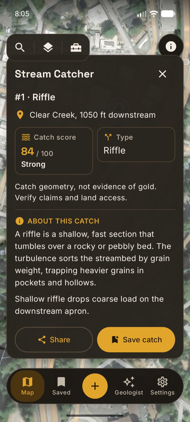
Stream Catcher on Android. Illustrative result; the displayed score is not evidence of gold.
Read the channel. Understand the catch.
Stream Catcher helps you inspect bends, junctions, and riffles along mapped channels. The result explains the geometry and keeps Save and Share within reach. A catch score describes the modeled channel shape, not the presence of gold. Verify claims and access before visiting.
- The magic loop — share any geotagged photo and land on that exact ground in LiDAR. Unlimited.
- Full USGS LiDAR terrain — the supported USGS renderings; local survey detail varies. Lodeline Relief is Pro.
- The favorability score — 0–100 with the full factor breakdown, plus the heatmap overlay.
- Placer and lode modes — stream gold and hard-rock country, both scored.
- A Best-reaches preview — one full ranked scan of the creeks around you, on us.
- Mining-claim boundaries — BLM active-claim lines with links to the official record, because “is this claimed?” should never be a paywall.
- Contours, forest roads & the PLSS grid — plus satellite and hillshade basemaps.
- River flow & daylight — live USGS gauges and sunset time for the day you're planning.
- Track recording & folders — walk the ground and keep your season organized.
- 25 saved spots, photo attachments, Lat/Lon · UTM · MGRS, metric or US units — and your first three AI briefings on us.
Pro ($29.99, once) and Lodeline+ (the AI geologist) exist for the day you catch yourself muttering “I wish I had the federal mine records… offline… on a mountain.” That day comes for everyone. We’ll be ready.
Evidence you can inspect. Limits you can understand.
Lodeline keeps the evidence visible: terrain factors, mapped geology, and historical records have different meanings and limitations. A score is a model output, not a geological finding. Inspect its explanation, compare the source data, and save what you actually observe. No score or historical mine pin establishes that gold is present or that you have permission to enter.
Straight answers keep you sharp in the field — and they're why serious prospectors keep the app.
Choose the tools for your field day.
Start with the free mapping tools. Add Pro for the extended field toolkit, Lodeline+ for online services, or both when you need them.
| Feature | Free | Pro | Lodeline+ |
|---|---|---|---|
| Payment | Free | One-time purchase | Monthly or annual subscription |
| Terrain and scoring | Core tools included | Core tools included | Core tools remain available |
| Offline map packs | Not included | Included | Requires Pro |
| AI briefings | Three introductory briefings | Three introductory briefings | Daily allowance |
| Cloud backup on Android | Not included | Not included | Included |
Free
- Payment
- No purchase required
- Useful for
- Terrain views, favorability, photo import, track recording, and up to 25 waypoints.
- Keep in mind
- Three introductory AI briefings. A free account is required.
Lodeline Pro
- Payment
- One-time purchase
- Useful for
- Unlimited waypoints, offline packs, trips, export, and extended field tools.
- Keep in mind
- Pro does not require a Lodeline+ subscription.
Lodeline+
- Payment
- Optional subscription
- Useful for
- AI briefings, photo reads, trip-planning requests, and Android cloud backup.
- Keep in mind
- Online services have daily quotas. Pro and Lodeline+ are separate upgrades.
Public elevation data is free. Software adds tools for viewing, processing, saving, and using it. Choose from the workflow you need, not a promise about what you will find.
See the current offer in your app store before purchasing. For a practical comparison checklist, read how to evaluate map purchases and subscriptions.
Start free. Own the tool when you’re ready.
The scouting loop — LiDAR, the score, claim boundaries — is free. Pro is a one-time purchase that unlocks the whole field kit, and Lodeline+ is the only subscription: it keeps the AI engine running.
Free
Not a demo · a working prospecting kit.
- Full USGS LiDAR terrain + the supported USGS renderings
- The favorability score + heatmap — placer and lode
- BLM mining-claim boundaries — current records, not permission to enter
- Photo import, track recording, live river flow & daylight
- Up to 25 saved waypoints — plus your first three AI briefings and a Best-reaches preview, free
Lodeline Pro
Extend your field toolkit with a one-time purchase.
- Unlimited waypoints + trips & the dig log
- Offline map packs for no-signal country
- Best reaches near you — the creeks around you, ranked, any time
- MRDS mineral occurrences + parcel owner layer — historical mines, and county parcel lines with owner of record (select states)
- Lodeline Relief — proprietary hillshade for benches and old channels
- Water-flow overlay + transect & measure — see where runoff concentrates, cut elevation profiles
- Catch-finder + ground disturbance (beta) — also included with Lodeline+
- HD aerial imagery + bulk GPX/KML export — take it to any GPS app or Google Earth
Lodeline+
The only subscription · it keeps the AI engine running. Cancel anytime.
- AI geologist — grounded briefings + follow-up questions, 25 a day
- Photo reads — show the geologist a photo of the ground, 10 a day
- AI trip planner (5 a day) + area intel (10 a day)
- Downstream catch-finder + ground disturbance (beta)
- AI dig-log notes — a rough field note structured into a clean entry, 20 a day
- Android cloud backup — optional sync for saved field data; not yet available on iOS
Pro is a one-time purchase. Lodeline+ is a separate, optional subscription for ongoing AI and cloud services, with the daily quotas shown above. Prices shown are in US dollars; confirm local pricing, taxes, terms, and availability on your purchase screen. Canceling Lodeline+ ends its subscription benefits at the end of the paid period; it does not cancel a separately purchased Pro upgrade.
Straight answers.
Do I need an account?
Yes. A free Lodeline account is required. Creating an account does not require a Pro purchase or a Lodeline+ subscription.
Does Lodeline find gold?
No. Lodeline combines terrain and mapped context into a favorability index. It does not detect gold, estimate gold content, or predict whether gold is present. Inspect the factors and source limitations behind the score. Favorability is not proof of gold.
Is Lodeline only for placer gold?
Lodeline has placer and lode research modes. Placer mode emphasizes drainage and terrain context; lode mode uses regional geology and historical mineral context. Both support research rather than establishing mineral content at a point.
Is it a subscription?
The core app is free. Pro is a one-time upgrade; Lodeline+ is a separate optional subscription for AI and cloud services. Current US prices are $29.99 for Pro and $4.99 monthly or $24.99 annually for Lodeline+. Confirm the price and terms shown by your app store before purchasing.
Does it work offline?
Pro includes downloadable map packs. Save and test the required area and views before leaving signal, including closing and reopening the app in airplane mode. AI requests, cloud backup, and current land-status information require connectivity. See our offline preparation guide for a complete field check.
What data does it use?
Terrain uses public USGS 3DEP elevation data. Historical mineral records come from USGS MRDS. Android selects USGS aerial imagery for Free and Esri for online Pro use. Offline packs use USGS imagery. Attribution is available in the app. Resolution and coverage vary by location. MRDS records are historical information, not current mining claims or proof of gold.
Which phones does it run on?
Android and iPhone, US-wide (that's where USGS LiDAR coverage reaches). Lodeline is live on Google Play and the App Store now.
Can I dig anywhere it scores high?
No. A score is about terrain, not permission. Always verify land ownership and claim status, get permission, and follow all local, state, and federal laws before prospecting or digging. Lodeline helps you decide where to look — it does not tell you where you're allowed to dig.
Is my data private?
Saved field data starts on your phone. Accounts, maps, and feature activity use online services. AI requests send the relevant context, text, and any photo you select to Lodeline and its AI provider. Optional Android cloud backup syncs saved field data and AI conversations; backup is not yet available on iOS. Activity identifiers can be linked to your account. Read the privacy policy for details and deletion controls.
How should I compare Lodeline with other map apps?
Lodeline separates a one-time Pro field toolkit from optional Lodeline+ online services. Compare the features you actually need, their limits, current pricing, and offline behavior. Our Field Notes guide provides a small field test you can use with any mapping app.
Now on Google Play and the App Store.
Lodeline is officially live on Google Play and the App Store, free to download. Pro is a one-time purchase in the app.
Questions about the app? Email hello@lodeline.app.
Public terrain data. Your observations. A better research record.